

In recent years, drones have evolved from simple flying devices to advanced work tools capable of collecting complex data and supporting professional activities in a wide range of fields. At the heart of this transformation are payloads, i.e. sensors and equipment that can be carried by drones. Each type has specific characteristics, advantages and limitations, and the most appropriate choice depends on the mission objectives and expected results.
Traditional camera: the basis of every survey
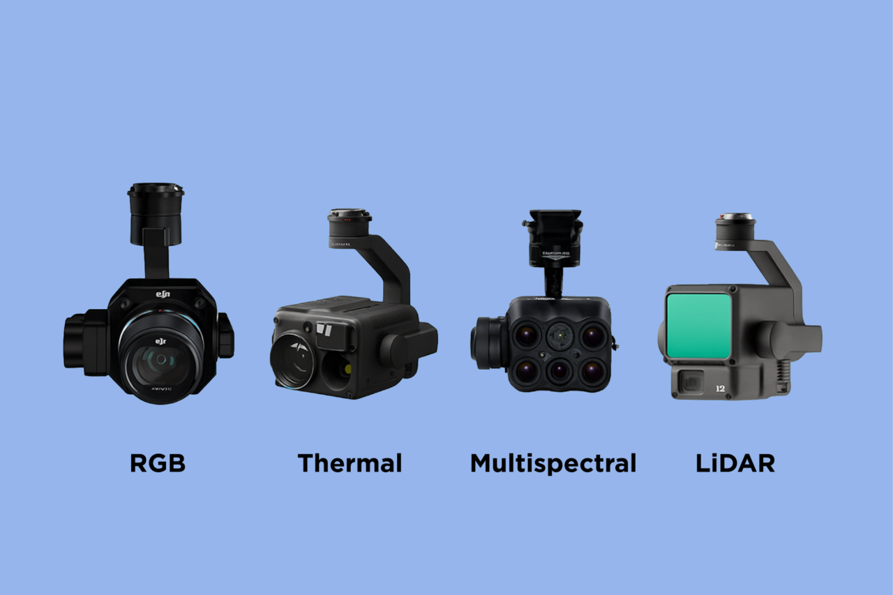
The traditional camera, often referred to as RGB, is the most widely used payload and is the starting point for many applications. These are sensors that capture images in the visible spectrum, similar to those of a common camera or smartphone. The data collected can be used to create orthophotos, 3D models and in-depth visual inspections. These cameras are lightweight, affordable and easy to integrate.
Their main limitation is that they operate exclusively in the visible spectrum, without the ability to detect thermal or other information that is not perceptible to the human eye. Furthermore, the quality of the results is strongly influenced by lighting conditions and the presence of obstacles or reflective surfaces. Despite these aspects, they remain the most widely used payloads in fields such as construction, basic agriculture, photogrammetry, visual communication and industrial inspections.

Thermal imaging cameras: detecting and measuring temperature
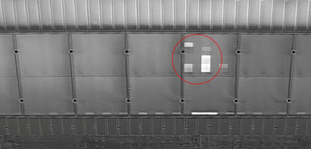
Thermal imaging cameras detect infrared radiation emitted by objects and translate it into images that represent temperature. This payload is particularly useful for detecting thermal anomalies, energy losses, overheating or the presence of people and animals in conditions of reduced visibility.
The main advantage is the ability to detect information that cannot be perceived by an RGB camera, a feature that makes them essential in areas such as energy efficiency, fire prevention, search and rescue, environmental monitoring and electrical inspections. On the other hand, they require accurate calibration and careful interpretation of data, as elements such as wind, humidity or materials with different emissivity can affect measurements.
LiDAR: the precision of point clouds
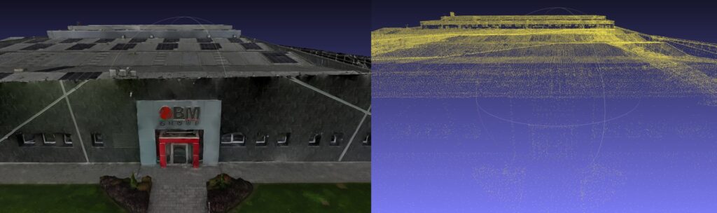
LiDAR (Light Detection and Ranging) is an active sensor that emits laser pulses and measures their return time after impact with objects. This allows the generation of extremely high-precision point clouds, ideal for reconstructing terrain, vegetation and structures, with a level of detail that photogrammetry cannot always guarantee. It also allows for the detection of much larger areas than traditional methods.
Its main strength is its ability to penetrate vegetation, returning terrain models even in wooded or complex environments. It is widely used in advanced surveying, civil engineering, forestry management and archaeology. Critical issues include the high cost of the sensor and data processing, as well as the greater weight, which requires more powerful drones. When accuracy is crucial, LiDAR remains the most reliable solution.
Multispectral sensors: tools for vegetation analysis
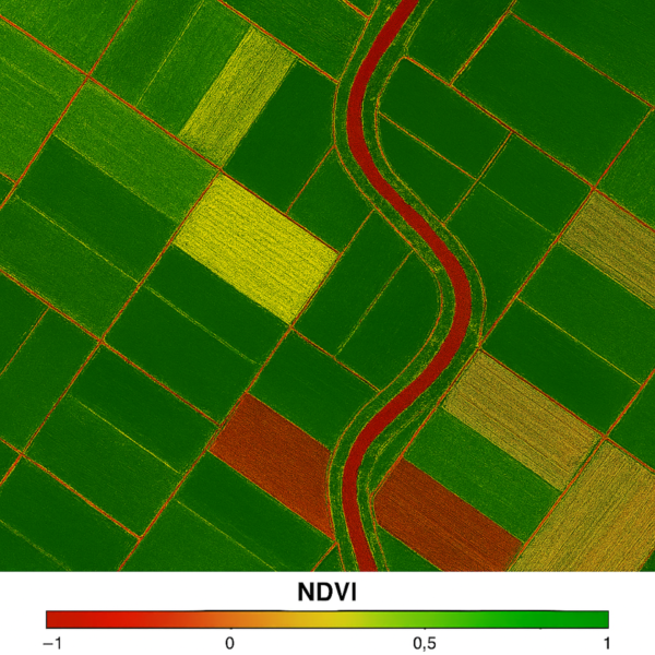
Multispectral sensors acquire data in bands of the electromagnetic spectrum that are invisible to the human eye, such as near infrared. This information allows for the assessment of crop health, water stress, the presence of diseases and the vigour of vegetation.
Their main strength is their ability to transform a simple flyover into an in-depth agronomic analysis, supporting precision farming practices and environmental monitoring activities. However, they require proper radiometric calibration and controlled lighting conditions to ensure reliable results. Furthermore, interpreting the data requires specific skills, which is why they are often used in collaboration with agronomists or specialised technicians.
Various sensors: other specialised payloads
In addition to the most common payloads, there is a wide range of sensors that can be installed on drones for specific applications. These include hyperspectral sensors, environmental sensors for measuring gas, air quality, humidity or particulate matter, acoustic sensors, radars, magnetometers and systems dedicated to infrastructure monitoring or scientific activities. These payloads are mainly used in research, advanced monitoring and industrial applications, where highly targeted information is required. Although less common and sometimes more complex to integrate and interpret, they further expand the versatility of drones, making them adaptable tools for a growing number of operational needs.
Conclusion
Choosing the most suitable payload is a fundamental step in obtaining reliable data and concrete results. Each sensor responds to specific needs and there is no one-size-fits-all solution: it all depends on the operational context, the available budget and the mission objectives. Understanding the characteristics of the different payloads allows you to fully exploit the potential of drones, transforming them into truly strategic tools for your field of application.